Nationwide Highway Network
Express Motorway (Kousoku Douro) network, limited access and divided lanes and maximum speed limit is up to 100km/hour (about 60 mile/hour), covers most part of Japan today, and it provides safe and speedy travel. But please note that it charges toll at so expensive price. For example, taking the expressway from Tokyo to Osaka, distanced 514 km (320 miles), you will be charged 10,650yen (almost $90) just for toll. Please don't compare the toll expense with that of NYC and Buffalo via NY Thruway or absolutely free-way between L.A. and San Francisco, otherwise you must be angry.
Express Motorway route is named after historical highway which parallels, the region where the motorway is running and so on and numerical system is not adopted at all.
Road exit is called "interchange" and specified by the place name where the interchange is located, although each interchange has an identification number for it (If you would like to identify an interchange by number, visit the website of "Route 901" with Japanese language kit in your computer). Road signs usually use "IC" for interchange, like "Yokohama-Aoba IC"
Express Motorways are constructed, operated and managed nationwidely by a single agent: the Japan Highway Public Corporation under the control of Ministry of Land, Infrastructure and Transportation (MILIT) of Japan.Major Bridges Connecting Islands
Bridge routes among major islands of Japan are separated in operation from the rest of the express motorway network for special skills to build and maintain world's longest-span suspension bridges to bridge the islands over the sea, however they are actually integrated into the nationwide network. This page distinguishes the next five routes from the other express motorways and highways because of this reason.Honshu and Shikoku
Kobe-Awaji-Naruto Motorway connects between Kobe (Honshu) and Naruto (Shikoku) via Awaji Island by two suspension bridges. Akashi-Kaikyo Oo-hashi bridge is the longest-span suspension bridge in the world.
Seto-Chuou Motorway bridges between Shimotsui, Kurashiki City(Honshu) and Sakaide (Shikoku).
Nishi-Seto Motorway runs between Onomichi (Honshu) and Imabari (Shikoku) stepping some small islands including In-no-shima, Oomijima and Ooshima.
Honshu and Kyushu
Kan-mon Bridge Motorway
This bridge is operated by a local division of the Japan Highway Public Corporation .Kan-mon Undersea Road Tunnel also runs between Honshu and Kyushu. This tunnel is operated as a part of national highway route 2, while the Japan Highway Public Corporation maintains it in practice for the technical reason.
The tunnel divides upper and lower decks. The upper is used for motorway, but the lower provides a route for pedestrians and bike riders to conquer the channel by their own foot.Honshu and Hokkaido
No road bridge or tunnel connects, but the longest undersea railroad tunnel in the world, Seikan tunnel, runs. You have to take toll ferries to land on Hokkaido with your car.
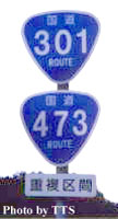 National Highway (Kokudou) network also covers the land of Japan and connects cities, towns and villages across the country. The roads vary from divided multi-lane express highway to sidewalk-like-narrowed single lane road. Highways are numbered, but the numbers don't indicate directions at all. Instead, the smaller number is assigned for the more principal highway: Route 1 is assigned for a route to connect Tokyo, the capital city, and Osaka, the second largest city in Japan, for example. 1-digit and 2-digit number highways connect major cities and politically and industrially crucial points. 3-digit number highways run among the other cities and towns and villages to bridge between 1-digits and 2 digits. Sheild-like or triangle-shaped markers are used to show route numbers.
(Right photo: The double triangle-shaped markers shows national highway route 301 and 473 overlap here. This photo was taken in Shimoyama village, Aichi.)
National Highways are basically maintained by the prefectures with subsidies by the central government. But, the central government sometimes takes care of highway segments cabinet orders specify. The specified highway segments are called "Seirei-Shitei Kukan". Another exception is that the central and local governments subcontract the Japan Highway Public Corporation to operate some roads because of technological and financial reasons.
Urban Expressways
To improve traffic conditions within urban areas, major cities shown below have city road authorities to operate urban expressways. Originally they built separated networks from inter-city highways, but now most of the urban expressways are integrated in the National Express Motorway network.
- Tokyo Metropolitan Area including Tokyo, Saitama and Yokohama,
- Nagoya Urban Area,
- Hanshin (Osaka) Metropolitan Area including Osaka, Kyoto and Kobe,
- Hiroshima Urban Area,
- Kita-kyushu Urban Area and
- Fukuoka Urban Area
Prefectural Highways and Municipal Roads
 Prefectural Highways access to cities, towns and villages within a prefecture. Principal Regional Roads and Prefectural Roads make prefectural highway network. Most Japanese people likely imagine two-lane non-divided road by prefectural highways, although they include various roads.
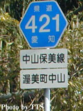
Like National Highways, Prefectural Highways use numbering system to indicate "grades" of roads instead of directions. The numbers are shown by hexagon shaped markers.
(Right photo: the hexagon shaped marker shows Aichi prefectural road route 421 named Nakayama-Homi line)
And also municipal roads reach to house to house. They are called by "Shi-dou" "Chou-dou" "Son-dou" or "Ku-dou" according to the kind of municipality which constructs and operates them.